Trans Canada Trail
Trans Canada Trail 2008 - Kettle Valley
10 June - Breakfast with the Harris's - Bob drove us to the trail head - about 30 km with the last 5 climbing on unpaved track. Depart about 9:12. A large water obstacle was crossed within the first kilometer. Shoes submerged while pedaling through. Rain coats worn for most of the day. Saw deer squirrels and cattle. Encountered a day riding couple from Idaho and a group of 8 and 2 tag-a-longs in a muddy stretch. Camped at Zack's Creekside camp at Beaverdell - no other tenters. Showers, etc. Chilli, ravioli and fruit cocktail for tea. Avg 14.8 km/h, 84 km, time 5:45, end odo 767.
11 June - morning temperature 3C. Breakfast of freeze dried bacon and eggs. Met a bicycle tourist from Arizona heading to Niagara Falls on a Trek 520 touring bike - already on the road for 7 weeks. We stayed at town campground in Midway. Purchased BC Trans Canada Trail book from the museum.

11 June - morning temperature 3C. Breakfast of freeze dried bacon and eggs. Met a bicycle tourist from Arizona heading to Niagara Falls on a Trek touring bike - already on the road for 7 weeks. Stayed at town campground in Midway. Purchased BC TC Trail book from the museum.
12 June - 2C morning temperature - Start odometer 852 km - on trail ~8:10, from museum ~8:30. A hard slog for 30 km to Eholt then downhill overlooking Granby Valley. Glorious views, sandy patches on the downhill grade. Lunch at the bunk house. Lost brake pressure / fluid and visited a bike shop in Grand Forks for repair. Loaf of sourdough bread from the baker neighboring the bike shop. Noon temperature 28C with a high around 30C. Arrived Christina Lake around 7:00PM - Ice cream while waitress phoned around to find campsite at the RV park. Grocery store and laundry closed. Cook not in - so missed the best burgers in the area. Pasta meal and dessert at the Greek restaurant. Distance 82.34 km, Average 15.5, time 5:18
13 June - depart ~ 7:30 - Groceries from the gas station. Did not want to retrace the route to the rail trail so followed the highway on an uphill slog for 27 km to Polson Bridge and more uphill to lunch at 37 km. Lunch of smoked oysters, sourdough bread and root beer. Filtered creek water. Tunnels - longest was 910 metres - and shared track with ATVs. Downhill track overlooked Arrow lake. Passed 2 other cyclists in one tunnel. Lower Arrow Lakes for the last 15 km into municipal camp at Robson - showers - laundry in sink. Food and beer from gas station. Slurpies from the servo, stew for supper. Average 16.3. distance 89.5, time 5:28, end odo 1028.5
14 June - Saturday - morning temp 3-4C. Windy overnight - 3 inch diameter cottonwood branch landed within 4 feet of my tent - "you OK Grant?" - "OK". The laundry lines in the pine trees held - Ken retrieved his laundry during the night. Scrambled eggs for breakfast - boiled eggs for trail snacks. Depart Robson ~ 11:00 following highway 3A to Nelson - 45 km. Fine weather, power generating stations along the Kootenay river/lake - tour of Nelson before finding the campground ~ 3:00PM. Alfresco meal of salmon on the main street with a large 9% La Fin du Monde- Quebec beer. Strawberry and rhubarb pie, washed bikes and cleaned gritty gears and chains. City campground was noisy with kids and crows, but no rooster. End odometer1075.8
15 June - morning temperature 4C. Depart Nelson ~ 8:15 arrived at Balfour ferry in time for the 10:00 departure. A steep rise out of Kootenay Bay. Groceries at the Gray Creek general store - operator from Bradwardine Manitoba. Pass closed - trail bikes tried Saturday evening. Camped at Lockhart Beach Provincial Park - the nearby creek provided white noise to offset the highway noise and provided a cold air drain as well. No showers so swam / dipped in the snow melt lake - numbingly cold. Early supper at the Italian family resort restaurant - spaghetti & meatball and a better quality rhubarb and strawberry pie End odometer 1137 km.
16 June - Monday - morning temperature 2C. Depart ~ 8:15 mostly hilly terrain along highway 3A. Lunch in Creston - burgers long break at Dairy Queen. Took the flat-cut into Creston via Lower Welvem road about 11 km west of town on the plains. Break at Kitchener for large cinnamon bun halved. A 7 km hill before Yahk - G2 gear. Camped in Riverside park - dandelion patch campsite. Turkey tetrazini, rice and tomatoes for supper. End odo 12139.5, time 5:28, Average 18.1
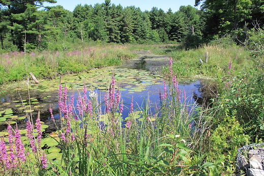
17 June - Tuesday - morning temp ~2C. Scrambled eggs with cheese and tomatoes for breakfast. Followed rolling highway 3 to Moyie Lake Provincial Park then back roads with rough patches into Cranbrook. Nice lunch break spot near lake / pond with water lily pads. Cirrus clouds in morning with clouds accumulating in the afternoon. Ken's mom broke hip and arm 4 days ago and waiting for operation. Ken decided to go and provide family support after conferring in the evening. Made bus arrangements, found a bike shop for packing. Municipal campground with the tent section across creek. Downtown area in decline due to box stores. Average 18.3, distance 72.8 km, time 3:57, end odometer 1312.
18 June - Blueberry muffins and coffee for breakfast, farewell to Ken at the Columbia / Bike store ~ 8:30. Methyl from the paint department of Home hardware for my stove. Followed Highway 3 to Wardner and Trans Canada Trail to Baines Lake. 4 km tour around and did not find "down town" and on to Elko. Camped at RV Park / Motel near general store. No hot water for washing / shower. High thin cloud in late afternoon. Average 18.2, distance 94.93, time 5:12, end odometer 1407.3
19 June - Thursday - depart Elko ~ 8:00, 0C morning temperature, 3 minute noodles for breakfast. Had muffin with coffee at Tim Horton in Fernie. Coleslaw and bananas for lunch in Sparwood. Purchased beer in Coleman before camping at Lost Lemon RV park in Blairmore. Arrived ~ 5:00. Mostly gentle uphill to Crowsnest Pass then generally downhill with a favorable wind. Mainly overcast. 16C at 6:00 PM. Laundry and shower. Average 21.4, distance 104.65, time 4:53, end odometer 1513.8
20 June - Friday, 0C morning temperature. Depart Blairmore ~8:00 and decide to go to Fort McLeod and bus to Calgary. Stopped at an auto parts Greyhound agency to determine the bus schedule, etc. 95 km ride plus town kilometres. Lack or town organisation is similar to Cranbrook. Visitor centre was not aware that the bus station was closed till a new location was developed. Spoke with bus driver who advised that a boxed bike would be loaded. I purchased tape, box cutters and pedal wrench for bike packing. A building renovator near the depot said I could use their spare cardboard. West Indies fellow painting the restaurant next door. The owner next door offered tape and tools and would store the box parts overnight for morning assembly. The building owner was touring cyclist - recently bought a Dutch touring bike from California - typical distances 125 km per day. Lots of mosquitoes in caravan park. Beer not sold in single cans - the 1.1 litre bottle of 10% alcohol Black Label was dumped. The beer store resembled a jail cell with a small window through which the grog was passed. Average ~25, distance 117 km, end odometer 1630
TC Trail 2010 - Banff AB to Surrey BC
15 July 2010 – Winnipeg to Banff – Arrived around noon, baggage OK, and bus to Banff departed 13:30. Driver very helpful in identifying a bicycle assembly location and pointed out the Post Office location. Driver hopped over a 1.4 metre high fence to help me pass the bike over. Posted bike bag to Vancouver before 17:00, found fondue fuel in one store then got back country and camping pass for SP 6 after two suggestions by parks staff that it was the closest back country camping to Banff – instead of my plan to ride 30 km to the provincial park campground on Spray Lakes. Departed for camp around 19:00 passed by Bow Falls on the way and made a wet shoes creek crossing (horse path) before getting on the bike / pedestrian part of the trail. Not much light left for setup and meal preparation, in bed around 22:30. I got water from the river near the tent. The bear poles and cooking area about 50 meters away, across the trail. On the morning departure found that the designated camping area was about 100 meters farther along the trail. My mattress of sphagnum moss was the best tent base I had to date.
End odo 20757 Time Distance 10 Average

16 July 2010 – SP6 (Banff) to Lower Kananaskis Lakes campground. Hard hills on the Banff trails. Chose the gravel road south of the Spray reservoir rather than the fire track north of reservoir – after the Canmore junction. Paved road for the last 18 km of the day. Bolton Trading Post had no fresh fruit or vegetables. Campground had no showers or hot water. Had a walk in campsite with bear boxes reasonably close. Two bicycle tourers in the adjacent campsite were finishing the 8 week Continental Divide trail. One from Chicago, the other from Netherlands.
End odo 20839 Time 5:35 Distance 82 Average 14.6
17 July 2010 – Lower Kananaskis Lakes to Elkford – Steep sections at the start of the Elk Pass track and a constant grade along the power line track to the pass. Inspected Tobermory Cabin – free – quaint and rustic. Arrived Elkford in time to get groceries and fuel before 18:00 closing. The municipal campground was filled with RVs and large 5th wheel trailers. The campground volunteer host was warning me about the unlikely encounters with bear and mountain lion. When I got to my site about 30 meters away the neighbours asked if I had seen the grizzly and two cubs outside the fence about 30 meters away another camper warned that the bears were in that direction from my location. The neighbours considered sleeping in the truck that night and offered me a hard storage place for food. Someone later said that the bears went to check out the deer carcass that was between the post office and mini mart (about 200 meters away). I chatted with the neighbour while he serviced his 45 pound downhill mountain bike. I showered and did a small laundry.
End odo 20922 Time 5:14 Distance 83.36 Average 13.9
18 July 2010 – Elkford to Fernie – Arrived Sparwood before noon and located the Greyhound depot. One bus daily departing 0340. I needed a bike box so proceeded to Fernie. Purchased materials for packing bike – in case no bike box to be found. Bike shop left me a nice / compact box which I picked up later. Campground was several km from town and bus departure was 04:00. I decided not to camp and pack up at midnight. Had a late meal at Boston Pizza and sheltered in the nearby arena exit waiting for the bus. Packed OK.
End Odo 21018 Time ? Distance 96 Average ?
19 July 2010 – Fernie to Chute Lake - One other passenger for pickup at Fernie, I got tickets and freight sorted at Cranbrook (?). Me $84.76, bike $42 thanks to the compact bike box. Changed to the Osoyoos / Penticton bus at Rock Creek. Bike re-assembled in Penticton by 15:30. Did not find grocery store before leaving town. Followed the TC Trail for the first ~ 20 km, Up hill and loose, sandy surface along the TC Trail – small chain wheel all the way. Refilled at Robertson (?) creek and followed the steep road for the 5 km before rejoining the TC Trail. Arrived at Chute Lake forestry service campground around 21:00. No bear boxes or bear poles and I disposed of my bike packing rope in Penticton.
End odo 21052 time 3:36 Distance 34.37 Average 9.5
20 July 2010 – Chute Lake to Summerland – rode with day pack back up to Myra Park boundary, 17 km each way. Knowing the track condition, Kelowna would have been a better start point than Penticton. Packed up and rode 20 km down the trial before switching to the Chute Lake road which soon became paved and was mostly down hill to Penticton. Late Subway lunch and on to Peach Orchard Road campground in lower Summerland. The grocery store was a hart 12 minute uphill ride. Bread, camambert, fresh fruit, etc.
End odo 21154 Time 5:44 Distance 102 Average 17.8
23 July 2010 – Princeton to Coquihalla Lakes – Followed TC Trail to Brodie Station – no services at Brookmere, so decided to continue while looking for a suitable camp. There was ATV trail damage on many sections. I continued to Coquihalla Lakes Lodge – supposed to have camping but said to be closed in 2005. Rough camping site and wash in the lake.
End odo 21376 Time 7:29 Distance 96.87 Average 12.9
24 July 2010 – Coquihalla Lakes to Hope BC. Followed the Pipeline road for the first 22 km. Met father and son (Art and Shaun weekend touring from Brookmere) on that section and stayed together until Hope. Good company and enjoyed the slower pace. Almost missed the bridge to cross the Coq river to the Quintrix tunnels and Coquihalla gorge. Shared a double site with a family of 3 relocating to Hope. Met a bicycle tourer travelling to Nelson High School Reunion (met one other on the TCT).
End odo 21446 Time 5:00 Distance 70.29 Average 14.0
25 July 2010 – Sunday late start – Hope to Lake Errock “The Campground” 20 km east of Mission. Followed Highway 7 north of the Fraser River. Temperature in the low 30s, clear and sunny. Lunch and museum in Agassiz. Lake Errock gas station had some groceries (chilli) and methyl alcohol. Near the rail line – lots of train traffic. Small laundry,
End odo 21511 Time 3:41 Distance 64.93 Average 17.5
26 July 2010 – Lake Errock to Surrey – Highway riding along Hwy 7 which usually had a good paved shoulder. Got brochures from Mission visitor information centre. The approaches to the Golden Ears toll bridge across the Fraser river indicated no bikes allowed, checked at the VIC – no real help other than bikes were allowed on the bridge. Got to the bridge and there was a suitable bike and pedestrian lane. Low 30s, clear and sunny weather. T&T asian supermarket was a pleasure to shop in. Ground pork, bokchoy, capsicums, ice cream, raisin buns and butter.
End odo 21601 Time 5:04 Distance 89.61 Average 17.7
Yukon and BC 2012 - Trip Log
Wednesday 6 Jun 2012 Start Odometer 1642.7 Tire circumference 2200 mm Flight connections OK. Calgary to Whitehorse departure changed to 21:30. Arrived, bike OK, assembled and at camp ground after midnight. In bed by 01:45. Stayed at Highway RV park.
End Odometer 1645
Thursday 7 Jun 2012. Awake at 05:45 shower and sorted packs and in to town before 07:45. Superstore open – food for up to 5 days, Metho from Home Hardware. Breakfast at McDonalds. Cash from TD CT. Packed and on road by 11:15. First let up in drizzle was at Jakes Corner. Bush camp about 100 metres from the store / cafe. It was a challenge to throw weight and rope over a sufficiently high poplar branch to lift the food bags above bear reach.
End Odometer 1740 Distance 90 Time 4:0 Average 22.3

Friday 8 Jun 2012 - Cloudy during the ride. Rain jacket on all day. Met French bike tourer after lunch and shared tips while he had lunch. He started in Vancouver on a Surly Long Haul Trucker and cycled more than 2000 km on Vancouver Island before taking the ferry to Prince Rupert and then following the Stewart / Cassair highways to Watson Lake. Destination Inuvik, Canol Road then Mackenzie highway to complete a loop. I arrived at Teslin before 17:00 and found that the highway to Watson Lake was closed due to washouts about 130 km from here. I will ask permission to proceed to arrive in time for the predicted re-opening on Monday.
End Odo 1842 Dist 102.19 Time 5:27 Avg 18.8
Saturday 9 Jun 2012 – Teslin, fine sunny and calm weather. No access allowed past the Teslin bridge. Visited the George Johnston Museum, did the historic walk by bike and took photos. Camp neighbours – from Yellowknife had been on a 4 day retreat a 30 km boat ride out of Whitehorse. Dean is the energy efficiency advisor for the bands / communities in NWT. He did a solo bike tour Vancouver to Oakville when he left the navy – adverse winds across the prairies. “So many avoid solitude ... they are afraid of themselves...”. Bailey bridge and culvert components passed through during the night. We get updates from the flag person and know the site supervisor.
End Odo 1853 Dist 10.96 Time 0:54 Avg 12.1
Sunday 10 Jun 2012 – Teslin waiting for road to re-open. Visited the Tlinkit Cultural Centre, laundry, high dry clouds moving in the afternoon. Did the George Johnston walk in the afternoon and returned with a German couple on the way back. More arrivals at the camp ground after the Skagway road re-opened. Commercial vehicles and Rancheria traffic are expected to be allowed to depart tomorrow.
End odo 1859 Dist 5.9 Time 0:28 Avg 12
Monday 11 Jun 2012 – in Teslin waiting for road to re-open for the third day. Over 30 trucks with new arrivals from Whitehorse. Many people on first name basis now – and who got the flagman updates most recently. Trucks finally started after 9.00 PM followed by the anxious and committed. I stayed overnight as did the Nanaimo bikers, Mark and Kevin.
End Odo 1859 Dist 0
Tuesday 12 Jun 2012 – cold overnight around 5C. Cloudy with some drizzle and a favourable breeze through the day. Departed before 08:00. Catch-up traffic flowed in both directions. After catching up on some missed kilometre during the day I camped at Rancheria Falls Recreation area. Pit toilets, creek water nearby, picnic shelter and two fairly obvious camp positions either side of the picnic shelter.
End odo 1995 Dist 136 Time 6:55 Avg 19.6
Wednesday 13 Jun 2012 – Cold overnight and no rain for the fist 15 km. Passed the washout where they were installing traffic signals on the single lane section. Saw one of the flag persons from Teslin at Rancheria cafe. After lunch met an northward bound New Zealander bicycle touring - Vancouver, Prince Rupert, and Sewart Cassair highway. Rain gear on form most of the day. Grilled ham and cheese sandwich at the cafe at the junction of highway 37. No Big Creek camp ground found 40 km west of Watson Lake. No tent camping in Watson Lake – provincial park 8 km back. Shopped for groceries and decided to proceed eastward and find a bush site with creek water for camping. I rejected a gravel pit area with bear and moose droppings and cycled until 20:40 and found a sand pit / dugout with no water. Put food in bags and hoisted into poplar tree. No water for cooking. Road noise from highway resumed in the morning.
End Odo 2172 Dist 175 Time 8:36 Avg 20.6
Thursday 14 Jun 2012 – mild temperatures overnight, woke several times during the night but no wild life. Had breakfast lunch and supper at creek crossings. Fireside camp ground not open. Truck driver advised of 3 bears east of Fireside so I chose to camp covertly behind the road maintenance materials shed.
End Odo 2280 Dist 108 Time 5:48 Avg 18.6
Friday 15 Jun 2012 – Overcast with sunny breaks. Warmest cycling day so far. Rain jacket off in mid morning. Stopped at Coal River for laundry, shower, water and cinnamon bun. Cleaned and lubricated the bike chain at lunch break – running much quieter. Longer and more frequent breaks due to ankle and knee pain. Saw 4 bears and one bison herd plus other bison. Saw a marten in the Hot Springs area. Previous day saw two black and one grizzly bear and four bison. Liard Hot Springs provincial park camping. Bear box delivered to site for food storage. Soaked in the hot springs pools before tea. Phoned Mark in the evening.
End odo 2361 Dist 81 Time 4:26 Avg 18.3
Saturday 16 Jun 2012 – lots of traffic in both directions, overcast with a head wind. Drizzle cleared a Muncho Lake. One bear, one moose seen. In the northern Rockies now, steep grades – Smart Car driver was impressed with my grade climbing. Camped about 24 km short of Toad River community.
End odo 2462 Dist 101 Time 6:33 Avg 15.4
Sunday 17 June 2012 – 24 km to Toad River, 2 cinnamon buns and water to go. Uphill 2 and downhill 1 pattern repeated on the way up to Summit Lake then generally downhill. Rain showers in the late afternoon. I was down to a single jersey for about 5 km during the afternoon. Thin horn sheep, goats and moose among the wildlife. Camped at a horse oriented site (Musqua conservation area) in about 30 km past summit Lake past the two Tetsa River bridges.
End odo 2561 Dist 98 Time 5:40 Avg 17.3
Monday 18 Jun 2012 – Packed up before rain started, waited 30 minutes in the shelter of trees for the rainfall to ease, only slight improvement. Stopped at the Tetsa RV Park for famous cinnamon bun and coffee. Rain and drizzle through the morning. A long climb to Steamboat mountain then descent. Saw three black bears. Creeks silty to the east of Steamboat. Did not find suitable camp at Kledo Creek rest area about 40 km before Fort Nelson so continued on to TripleG camp. Found Laundry and shower. Finished the food except for a Granola bar, ½ soup and ½ tomato paste from Watson Lake. Plan to shop early. Sunset getting noticeably earlier as I proceed southward.
End Odo 2681 Dist 120 Time 6:09 Avg 18.5
Tuesday 19 Jun 2012 – into town around 07:00 for reconnaissance. No “down town” area – just linear development for retail services with industrial off to the sides. Groceries at Overwaitea – fondue fuel from Home Hardware. Purchased 3 days provisions and hoping for some supplies along the way. Creek water is cloudy so I will start with 2 litres of water tomorrow. Favourable breeze during the day, sunny with clouds forming locally. Brief showers but not enough to put on the rain coat. More bugs, mosquitoes and flies. Smooth paved shoulder all day. Prophet River looks abandoned with about 5 habitable transportable dwellings. RV park was not the kind people choose to stay at; prtaloos and no water supply. Native residents were helpful and welcoming. Pre-teen kids rode around on quad bikes. Pick-up truck going to the creek for a swim but kids pile onto the quad bikes rather than ride in the back of the truck. No one complained about cold creek water. Free camping for cycle tourers so I picked up rubbish around the yard to reduce the “broken windows” temptation of throwing more rubbish in an untidy area. Two large gas / compressor sheds on moving trucks in the yard – the moving team assembled after sunset with departure after 23:00. I moved out of my tent while they raised to overhead power lines to allow the equipment to pass under. The heavier building had one puller and one pusher prime mover. End odo 2790 Dist 109 Time 5:46 Avg 18.9
Wednesday 20 Jun 2012 – fine weather with cloud increasing. Dusty section of road construction after 15 km. Gaining elevation through the day, unfavourable winds. Only 2 bears seen. Bucking horse River Lodge offered free camping for bicycle tourists. (Provincial park camping available nearby with pit toilets, etc.) Veal special from the cafe for tea. Received emails but the outgoing mail would not execute.
End Odo 2879 Dist 88 Time 5:52 Avg 15.0
Thursday 21 June 2012 – the summer solstice – fine morning with clouds forming. Thunder in the area in the evening. Some steep grades to Pink Mountain. Got chili and one beer at Pink Mountain. Got cinnamon bun at Sasquatch Crossing before the tour bus arrived for lunch. Camped at xxx mile camp – looks like a weekend and summer occupancy camp with mostly long term or seasonal occupants. The Mag and Mells “Free Camp” nearby was for gas field workers rather than tenters. No one present and I took a vacant site near to water and pit toilets. I spoke with the owners/builders in the morning, who arrived late in the evening. “How'd you sniff out this place?” It was on the old topographic maps and I thought it should at least provide flat ground for camping – compared to the communications tower on the hill across the highway which included a diesel powered generator (and noise) with no nearby water.
End Odo 2961 Dist 82.8 time 5:30 Avg 15.1

Friday 22 Jun 2012 – Good smooth shoulder on the road today, winds variable and grades not severe. Sunny with cloud increasing. To applications of separated sunscreen. Met three touring cyclists today. The first from Bellingham Washington through Sumas BC, Hope, Princeton, Prince George, etc. on a large tired mountain bike carrying an inflatable boat / raft and a large back pack. Andrew's destination was Inuvik and the Canol Road. The others – a grandfather and grandson from Texas on recumbent bikes – covering 50 to 60 km per day and bush camping when possible. They recommended the Shepherd Inn where I stayed that evening. I did daily shopping at Wonowon – bananas, chili beans and metho/fuel. Cinnamon bun on arrival at camp. Wide and oversize load escorted trucks are common in both directions. Now, log load trucks are common heading south.
End odo 3049 Dist 88 Time 4:41 Avg 18.8
Saturday 23 Jun 2012 – clear morning with single layer clouds forming. Rolling hills. Visited the museum in Fort St John. No tent camping there. Grocery shopping and on to Taylor. The flood damaged park had no drinking water, pit toilets, no wash basins etc. I met a French cycle tourer on his way to Dawson City – in the third year of his round the world tour. He will head to Perth WA next to delay the tropical heat in Malaysia, etc. Bratwurst and other sausage, capsicum and fresh bread for tea. Large cookies from Shepherds Inn and a 66 cl bottle of Stella.
End Odo 3123 Dist 72 Time 3:24 Avg 21.2
Sunday 24 Jun 2012 – Two long hills on the way to Dawson Creek. Visited the Art Gallery, Museum, Visitor Center. Did laundry and Grocery shopping. Stayed at the Mile 0 RV park about 2 km from the town center. Will collect bike bag tomorrow morning. Port tenderloin, mushroom and capsicum for tea.
End odo 3189 Dist 68 Time 3:50 Avg 17.8
Monday 25 Jun 2012 – packed and into town for 09:00 openings. Info center for maps and camping info. Post office for bike bag at general delivery. Alaska Highway Center / Museum and watched the PBS documentary. Stopped at Safeway for today's meals. Demmitt – camp ground is operated by the Grand Prairie council – 15 sites quite suited to tenting, pit toilets. Water from the nearby highway weighbridge was somewhat silty. No bears or live wildlife except hawks and birds. Well maintained beaver dam across the road.
End odo 3244 Dist 52 Time 3:05 Avg 16.9
Tuesday 26 Jun 2012 – chilly overnight. Packed dry, favorable wind. Stopped at Hythe and Beaverlodge for breaks. Beaverlodge better shopping than Wembley. Sausages and capsicum for tea, sticky buns and yogurt, wheat beer and polish beer from the beer and wine ship. Shower in camp ground Windy in the evening decided to move the tent to a more sheltered location. Found Wi-Fi on the streets to check emails. Change to Mountain Time zone.
End odo 3318 Dist 74 Time 3:16 Avg 22.8
Wednesday 27 Jun 2012 – Looked at Sunset Lake reserve before packing. Favorable windy conditions prevailed from previous day. Viewed the Visitor Center and Museum – very comprehensive. Camped 7 km north-west of the city center. Wall Mart shopping. Perogies for tea and breakfast with French vanilla yogurt
End Odo 3393 Dist ~ 35 (extra distance due to electronic interference from store Wi-Fi, etc.)
Thursday 28 Jun 2012 – Processed some photos and visited the down town area and several shopping plazas and centers. Found Canadian Tire and Safeway but shopped at Wall Mart again. Less windy today. More mosquitoes. Cleaned bike and did laundry. Hamburg beer, Holsten and draft Guinness. Chicken curry with green pepper and banana. Strawberries and baked goods for lunch.
End Odo 3427 Dist 34 Time 1:50 Avg 18.6
Friday 29 Jun 2012 – Cleaned and packed up before 09:00. Proceeded to airport and packed bike within 90 minutes. Met Bob N at the airport and had coffee until Pam arrived. Proceeded to Boston Pizza for lunch with Bob and Pam who returned me to the airport in time for my flight to Edmonton and Winnipeg. Arrived OK and met Sandra at the oversize baggage collection area and returned to her home. Stayed in the library bedroom.
End Odo 3442 Dist 15
Section Distance 1799
TCTrail 2012 Ottawa to Port Hope ON
Wednesday 18 Jul 2012 – left Sandra's place around 07:00, packed bike in 70 minutes and was a half hour ahead of schedule. Flight to Ottawa was on time. Re-assembled bike OK and posted the Tardis bag etc. to Port Hope. Nice rail trail with some aspen autumn leaves. No space at the Appleton camp ground, so I stayed at a vacant soccer park among pine trees within earshot of the Mississippi River. Past sunset before camp found around 20:30 – in daylight the next morning, the nearest visible houses were about 100 meters away. Sunrise around 06:00.
End Odo 3854 Dist 77 Time 3:52 Avg 20
Thursday 19 Jul 2012 – packed up damp in the morning. Loop route, winds not strong. Getting used to finding the Trans Canada Trail signs – Orange arrow on a cream background – consult the map, watch for signs ahead, check for signs behind at intersections. Temperature around 25C with high cloud. Old Perth Road was a nice ride. Mostly paved roads otherwise. Through Almonte (historic town with old mills,etc.), Lanark, Perth and Smiths Falls. Camped by the lock-masters house - $4.90 per night for peddlers and paddlers.
End Odo 3963 Dist 108 Time 5:20 Avg 20.3
Friday 20 Jul 2012 – Nice rail trail sections. Shared use (with ATVs) were rougher and sandier. Groceries at Sydenham, no camping at Harrowsmith. Did a 45 km road section between Harrowsmith and Sharbot Lake. Store closed at Sharbot Lake, proceeded 10 km down the rail trail – to Bass Lake. A pull off of the rail trail, or a beaver haul out provided a small space for the tent. Wild life was moving by dusk. Mosquitoes active after dusk. Sausage, onion, mushroom and tomato for tea. Coffee. Will treat extra water in the morning. Changed the rear tube due to a slow leak – maybe a wire fiber.
End Odo 4100 Dist 138 Time 7:21 Avg 18.7
Saturday 21 Jul 2012 – Bass Lake to Adolphustown – rough ATV trail to Kaladar. Tire / tube failure about 8 km before Kaladar – bead wire exposed and separated. Moved the damaged tire to the front and the good one to the rear. I added duct tape to help support the damaged bead area of the tire – and rode slowly into town. No bike tires in Kaladar so I abandoned the TCTrail plan. I added a C shaped collar from the mid section of a discarded water bottle to support between the tube and damaged area of tire bead – to spread the load. The lack of flex in the front tire was evident at 30 k/hr. Drinking water from Kaladar wash room was contaminated with hand soap from the tap. Humid and 25C, rest break by a river. I got a replacement 37mm Kenda tire from Canadian Tire in Napanee and installed it before departing on the 35 km to Adolphustown UEL camp where I stayed last year. Met two newbie middle age bicycle tourers from Newcastle with lots of baggage traveling 50 km per day on a one week tour. Couscous, turkey, cucumber and coffee for tea.
End Odo 4226 Dist 125 Time 7:01 Avg 17.9
Sunday 22 Jul 2012 – Humid overnight but the tent was packed up dry in the morning. On the road before 08:00. Light adverse wind, Giant Tiger shopping in Picton. After noon stop at Brighton swing bridge. Chatted with a kiwi electrician / sailor on a folding bike (which he carries on the sail boat). Groceries at Colbourne then back to Salem Woods tent and caravan park 3 or 4 km from the town center. Tires working OK. Tightened the head stem bearing and had a swim in the pool after setting up tent. Ham, cucumber, capsicum, tomatoes and noodle salad for tea.
End Odo 4322 Dist 96 Time 4:57 Avg 19.4
Monday 23 Jul 2012 – Packed up dry and followed the waterfront trail through Cobourg to Port Hope arriving shortly after noon. Beer and bread flour shopping in town before proceeding up the hill to Ralston Drive.
End Odo 4370
Section Distance 593
TC Trail 2013 - Mont Joli to Drummondville
29 May 2013 Wednesday – Start odo 19719. Bike bag packed and mailed to Drummondville Quebec on Tuesday. Replaced and shuffled light bulbs and compact flouro lamps. Packed and departed Port hope 10:45 and arrived at Cobourg Via station an hour before departure. A 1:40 wait and transfer time and supper in Montreal. The Halifax and Gaspe trains split in Levis / Quebec city with much slower speed on the Gaspe line. Some periods of rain while traveling. From SMS sent – Arrived Cobourg no rain. Bike checked thru to Mt-Joli.

30 May 2013 Thursday – Streets were wet in Mt-Joli when I arrived at 02:45. My plan for wild camping (nearest camp ground was about 10 km away) worked out – the airport area had a row of maple trees (from a former house I imagine) that provided a screen from traffic. One of the mid section tent pole segments got an end crimp making it hard to assemble / disassemble. Up at 06:00, packed and on the way to Grand Metis shortly thereafter. Went to the quai – Metis river mouth. Metis Gardens (tourist attraction) not open so early in the morning / season. Cool but calm with fog for the first 80 km. St Fabien municipal camp ground not yet open. Trois Pistoles – an extra 25 km to a nice large beach camp ground – with all season campers filling about half of the sites. The isopropyl alcohol burned with a sooty deposit on the pots – as usual. The daytime temperature was around 10C with an adverse wind for the last 30 km. Fixed the tent pole by moving the damaged segment to the end – where a plastic pin fits into the (damaged) end.
End odo 19836 Dist 117 Time 6:44 Avg 17.4
31 May 2013 Sunday – Showers overnight warming to a single clothing layer for part of the day. Adverse winds and slow progress. Sore legs and feeling somewhat lethargic (more typical of day 3 of tours). Food Purchased in St E? and Riviere du Loup on the way. Gulf and river views through the day. Heavy showers while in a picnic shelter in front of the church in St Andre. Another 5 km and found a camp ground. It rained for a couple more hours after camp set-up.
From SMS sent – On time into Mt-Joli. Wild camping near airport. To Metis early and MJ Timmys before shopping.
From SMS sent – Near St Andre. Rain and showers since 4PM. Tent working OK
End odo 19924 Dist 89 Time 5:41 Avg 15.6
1 June 2013 Saturday – Favorable winds and some showers – cool to cold. Packed wet and tried drying in the overcast skies at noon – without success. Montmagny offered camping and shopping so I went the extra distance. While fixing a glass rear tire puncture – I chatted with a solo tourer headed east the Gaspe – on a leisurely pace from Sherbrooke. Pork chops, peas and couscous for tea. Yogurt for dessert. Blasting shower.
From SMS sent – At Montmagny – 110km with favorable winds. Cool with showers. Packed wet in morning but dry now.
End odo 20035 Dist 111 Time 4:58 Avg 22.4
02 Jun 2013 Sunday – Cool and windy overnight. Storms and flooding made the Quebec City news headlines over several pages. My site was sheltered from the winds – which became calm to favorable in the morning. Some heavy showers around noon and could see could see the bright sky / clouds on the horizon. Followed highway 132 to an Autoroute then found my way across. Could see the shape of the sun behind the clouds in the late afternoon. No camp in St Agapit. Rode 8 km north to where map indicated where a camp used to be. Third try and I found a seasonal park with a couple of tent sites where they moved in a table for me. Treated the non potable tap water. Fish, corn and couscous for tea with a dark local beer.
From SMS sent – Stopped raining but showers forecast overnight. About 120 km cycled – 12 to find the camp ground.
End odo 20159 Dist 123 Time 5:56 Avg 20.9
03 Jun 2013 Monday – Cool with a few sunny breaks. Followed a rail trail (TCT) after 20 km into Victoriaville. Trees helped to break the adverse winds. No camp found at a google map location – add 15 km of unproductive distance. Too late to make the 30 km to Kinglsey Falls. Camp near Chesterville was 15 km to the west and would require another 15 km to get back on the trail. Rustic camp ground for weekend and seasonal campers. Office closed and the resident-in-charge said I could stay the night no charge. Met a hiker from Florida planning to hitch across to BC – doing a trial camp in the area before departing. Figured out the route to take to get back on course for tomorrow. Phone and camera batteries all charged.
End odo 20273 Dist 113 Time 6:32 Avg 17.4
04 Jun 2013 Tuesday – Dry overnight and on the road by 08:00, navigated the back roads and hills to the TCTrail. Cinder / dolomite surface into Richmond through woods and fields. Muffins at Tim's for the last 40 km to Drummondville. Arrived in time to collect the bike bag from the Post Office. First camp ground (according to map) no longer there. The second was near the river and autoroute and close to town. Tall pine trees and I was the only camper in my zone/section. Sunny breaks in the afternoon. Sausages and carrots for tea, yogurt for dessert. Bavaria style Dutch beer.
From SMS sent – Mostly cloudy with light adverse wind.
End odo 20396 Dist 124 Time 7:12 Avg 17.2
05 Jun 2013 Wednesday – Drummondville, touring locally, modern photography museum, and preparing bike for travel. Drummondville has been stretched lengthwise by shopping centers on the outskirts. The older Promenades shopping centers (strip mall in an L shape) was not vibrant but had box stores and small business activity in the area. The down town core was still active with small shops and a nice town square. Partly cloudy with a high around 20C. Meat (finely ground of some sort) ball stew and vegetables for tea, Bavaria beer again. I checked with the Via office and will take the 07:18 train which will stop at Dorval.
From SMS sent – Cloudy but good weather.
End odo 20427 Dist 31 Time 2:20 Avg 13.5
06 Jun 2013 Thursday – From SMS sent – Partly cloudy 20C still a 2 layer day. Ready to be at Via station 07:00. Arrive Dorval in 2hr lots of time.
TC Trail 2014 - Montreal to Ottawa
06 Jun 14 Complementary breakfast at the hotel. Navigated to Bois des Filions, the start of the Petit Train du Nord (Green Route 2) Shopped and posted bike bag about 30 km from departure. Shopped again in Val David. Paved surface ended at St Jerome and packed chip surface was OK. Laurentians guide indicated a camp ground at Val David – on highway 117. It had a few customers in the "early" season.
End Odo 1332 Dist 119 Avg 17.4 Time 6:52

07 Jun 14 to Nominingue. Rail trail with gentle but noticeable grades. Mostly paved surface with some corrugated areas. Rocky outcrops and swampy areas. The smell of queen ann lace flowers and strawberry blossoms. Some B and Bs or Gites for tourers. Spoke with a family of 4 with 2 kids under 5 on tag along tandems. Clear and warm – single layer top. Mosquitoes when stopped in the country. L'Assomption IGA for main shopping. The camp ground was unsigned from the main road and I rode and extra 7 km following signs to a children's camp.
EndOdo 1451 Dist 120 Avg 18.5 Time 6:29
08 Jun 14 to Lac Glenon / Messines. Paved rail trail to Mount Laurier then followed the Highway to Grand Remous. 14 km southward on minor roads to Almond. Camp not open and invested with black flies. Bought Watkins 28% DEET aerosol for $17. No camp at Deleage. The road through the Indian Reserve needed maintenance. I continued southward and found a camp ground at 140 kms. Sunburn, mozzies, deer flies and black flies. The deer flies make their way through the air vents in the helmet and bite my head – before I can dislodge them. The pleasant francophone custodian of the mainly seasonal camping area assigned me an unofficial site and table next to the lake and close to amenities – at the attractive price of free.
EndOdo 1593 Dist 141 Avg 18.8 Time 7:30
09 Jun 14 to Gatineau National Park. I followed the marked trail to Low and followed the a "bike path" which took me back to the river road after 6 km. There was constriction and road works around Wakefield. The TCTrail route was through a school grounds – no marked trail and chain link fences. I passed through the renovated covered bridge at Wakefield. The Valley Road detour took me back to the 4 lane divided highway. To get down to the bike tail I had to lift the bike over a guard rail, and walk over unfinished construction slopes. The Phillips Lake camp sites $39 per site was landscaped with no other campers in view. Occupancy was probably 1%. Black flies were not so bad but deer flies and mosquitoes were persistent through the day. End Odo 1703 Dist 110 Avg 16.1 Time 6:48
10 Jun 14 to Ottawa Airport Rideau Heights. I followed the Trans Canada Trail along forest tracks for about 15 km. I ended up at the edge of the park after a long decent. The map indicated it was about 3 km back to the TCT single track mountain bike trail. I proceeded on the paved minor roads from there. In Ottawa I collected my bike bag from the central Post Office and followed the riverside bike paths past Bells Corners to link with the TCT section that I rode in a previous year. EndOdo 1781 Dist 78 Avg 15.1 Time 5:07
11 Jun 14 Rideau Heights caravan park. I did laundry, bike cleaning in the early morning before shopping. Rain set in from around noon until 20:00.
EndOdo 1793 Dist 13 Avg 16.1 Time 0:47
12 Jun 14 to Winnipeg. I did bike cleaning and packing until Fred arrived around 09:20. We had coffee at Tims and visited a BMW motorcycle store. We visited the Experimental Farm Arboretum before collecting Heather from work and had a delightful Vietnamese lunch. Fred dropped me at the airport around 13:40. As rain showers set in, I moved indoors near a cleaners area for bike packing. By 15:00 I was checked in and through security in plenty of time. Sandra met me near the baggage area in Winnipeg. I assembled my bike in the evening at Sandra's home.
TCTrail 2017 Vancouver Island and Sunshine Coast BC
21June17 Wednesday. Portage la Prairie MB to Sidney BC. The bike was packed the previous evening. Departed Portage around 08:00 with Lynn, Mark and family. Croissants at La Belle Baguette, chocolate shop, music store and Costco shopping before going to airport. The incoming flight was 10 minutes late due to lightning in the area, another 30 minutes delay after loading. I missed the Edmonton to Victoria connection. I arrived Vancouver 19:30 and the flight to Victoria was at 22:30. I assembled and packed the bike by 23:55 and rode 20 minutes to the Sanichton Super 8 and was in bed by 00:35 local time. It was light outside at 05:00 and I got up at 05:30. Muffin for breakfast
End Odo 41984

22June17 Thursday. Departed Sanichton around 06:44 on a nice bike trail / route to Quadra and then city streets to Beacon Hill Park then around to the east side of the harbor and down town until 08:50. I met Henry Phillips at Chez Cora for a hearty breakfast and chat. I mailed the bicycle bag to myself at General Delivery Nanaimo. Henry accompanied / led me on the Galloping Goose trail to Colwood. We did a quick tour around Royal Roads University and continued on the GG trail to Metchosin for lunch. Henry returned to Victoria – about 32 km there. I cycled a lovely section of GG trail to within 3.5 km of Sooke. I shopped for food, fuel and beer then went on to Sooke River Flats campground about 11 km from Sooke Potholes campground.
End Odo 42069 Dist 85.23 Time 5:35 Avg 15.28
23June17 Friday. Sooke to Sombrie Beach. I slept till 08:00. A sunny day and departed around 09:40 and did grocery shopping before 10:00. I took breaks at Shirley, Indian River and the marine trail to Juan de Fuca beach camps (hiking trails). There were some steep creek crossings on Highway 14, walked on some of them. There were festivals at Sooke and Port Renfrew that weekend – so more traffic on that Saturday. The Sambro Beach car park was about 500 meters from the beach camping. There were some serious ascents to get back to the highway. I chose a sheltered campsite with a beach view and a tree trunk 1.2 meters diameter.
End Odo 42134 Dist 65.51 Time 3:49 Avg 17.15
24June17 Saturday. Sambrio Beach. Humid and cool overnight, another clear sunny day about 21C. I had a lovely view of the Olympic Mountains across the Juan de Fuca strait. I cycled in to Port Renfrew through rolling terrain and interesting creek crossings. Light traffic in the morning and more oncoming traffic on the way back to camp. Many once-a-year campers were taking advantage of the fine weather and beach-side camping only half a kilometer from the car park. Three trips from car to beach for most I suspect. Composting toilets and creek water were 100 meters from my site. Chili with beans and pasta for tea again. A finer grind of coffee would suit me better . I hope that the Sooke grocery store is open when I pas there. I saw a raccoon eating on the foreshore.
End Odo 42173 Dist 38.36 Time 2:31 Avg 15.28
25June17 Sunday. Sambrio Beach to Sooke Potholes Regional Park. I retraced my route to Sooke. I did not need to walk up any steep hills once on the road. There was some light cloud during the day, a single layer with sleeves up most of the time. I shopped at the Sooke Market, better selection than the Western Foods store and prices were comparable. I got 2 beers from the BC liquor store. It was about 11 km from Sooke to the campground. There was a bicycle specific camping area $15 per person, with nice tent pads, eating shelter, water and pit toilets. I swam and bathed at the potholes / river beach. For tea: ground pork with tomato puree with vegetables and apple sauce. No mobile phone reception here. I will cycle toward Duncan via Langford tomorrow.
End Odo 42244 Dist 71.23 Time 4:14 Avg 16.84
26June17 Monday. Sooke Potholes to Goldstream Provincial Park – west campground. I took the Galloping Goose trail all the way back to Langford. There were numerous day cyclists, dog walkers, some using horses and two ponies. I saw three deer south of Sooke Lake road. I shopped for groceries at Langford. Campsite neighbours were Sam and Rick – former navy Elec Tech from Fredericton NB who spent time at Equimalt.
End Odo 42291 Dist 47 Time 2:59 Avg 115.93
27June17 Tuesday. Goldstream PP to Duncan. I took Highway 1 to the Malahat then minor paved roads to the Trans Canada trail. There was a good cinder track to the Kinsol Trestle, I left the trail for paved roads 6 km before Duncan Riverside Caravan Park. I shopped at Save on Foods – pork sausage, green beans and rice noodles. I learned that the TCTrail track to Malahat opened last weekend but was not suitable for road cyclists.
End Odo 42348 Dist 56.79 Time 3:34 Avg 15.93
28 June 17 Wednesday. Duncan to Lake Cowichan and return. I got stove fuel from Superstore before leaving town. 10 km to the trail junction – a good road except for a kilometer so with baby head rocks, several mud patches. Fallen trees had been cleared. There were nice restored rail trestles on the outbound route. The inbound trail had less curves and creek crossings, with a gentle downhill grade. I met a Californian touring couple on a tandem bike with a Bob Yak trailer. (Victoria to Tofino, ferry back to Port Alberni then TCT to Sooke Pt Renfrew and Victoria). At Duncan, most of the RV sites were filled and most tent sites were vacant at 17:00.
End Odo 42417 Dist 69.16 Time 4:36 AVG 15.06
05 July 17 Wednesday. Porpoise Bay PP to Vancouver airport. I rose around 06:00 had breakfast and packed by 07:35. I chatted with John an ex infantry on an over night bike tour from Vancouver. We chatted again at the ferry terminal and he provide me with a guided tour from Horseshoe Bay to the Loins Gate Bridge. I found a familiar route through the city to the airport. I had plenty of time for bike packing at the airport . A smooth check-in and a light meal before the 20:30 Air NZ departure.
End Odo 42828 Dist 72 Time 4:16 Avg 16.89
06 July 17 Thursday. Date line day change
07 July 17 Friday. Landed at Auckland around 05:00 with enough time for a Burger King breakfast before the 08:00 departure. Smooth flight into Adelaide, cool and damp with rainfall over the city. Smooth passage through customs and quarantine. I assembled and repacked the bike in the bike area outside the old international terminal building. I took Henley Beach Road to the city and arrived home after 14:00 without rainfall.
End Odo 42850 Dist 21.04 Time 1:15 Avg 16.89
TCTrail 2018 – Calgary to Kananaskis Country
08 Jul 18 Winnipeg Overnight at Dave and Sandra's. Baked bread for breakfast. Beer and burgers for tea. Sunny
Dist 22.0
09 Jul 18 Winnipeg to Calgary. Ken drove me to the airport for lunch and departure. Check in went smoothly. I was in the infants section for the flight. Baggage was available about 30 minutes after disembarking. Bike assembly and packing took about 60 minutes. There is no grocery store at the Cross Iron Mall. I got pop from the gas station near the Balzac campground, no wifi. Visited with Uncle Colin and Gayle (from Didsbury) for about an hour. Chilly night, sleeping bag done up.
Dist 23.0

10 Jul 18 Calgary to . Packed up by 08:10 and back to find a Buck Or 2 store – none at the Cross Iron mall. Texted Eva and Gil to see if home. Phoned Gordon and Bev, when near by, no answer. Struggled to find a postal agent – Shoppers Drug Mart. No source for burning alcohol, so I got gasoline line antifreeze. I took a lunch break at Tim's during a downpour. Construction confused Maps.me and took me to an Indian Reservation road – permit required so I took Highway 20 with a good shoulder, hilly with adverse wind. I got water and a tin of tuna with 25km to go. Gooseberry campground had no water source, pit toilets and a bear box.
End Odo 47160 Dist 110.45 Time 6:42 Avg 16.5
11 July 18 Gooseberry CG to McLean Creek. Awoke at 06:00 then slept in till 09:00. There was well water for washing, etc. I rode into Bragg Creek for food purchases and found fondue fuel at the store, a 6 pack of beer and back to the campsite for lunch before packing. Next campground about 5 km away. No bear box - I will try a tree line using a rope I found. Mosquitoies not too bad. Partly cloudy. Washed the bicycle.
End Odo 47184 Dist 24.33 Time 1:30 Avg 16.15
12 July 18 McLean Creek to Little Elbow. Chilly over night and partly cloudy day. It was an ascending route, seldom had to dismount and push. It was highway most of the way. I stopped at elbow Hills, no bear boxes again. The 'walk in' tent sites were reserved for drive in campers. No potable water again, as usual now. I used the aqua tablets in drink bottles and well water for dishes and washing. Only two camp sites were occupied in the tent loop that I was in.
Dist ~38.0
13 July 18 Little Elbow to Sibald Lake Provincial Park. Chilly overnight, long johns and tuque by morning. Partly cloudy, wind variable. Up hill with walking sections for the first 10 kilometers, some walking in the next 15 km as well. Two nice resting points along the way. Gravel road for all but the first 1 and last 3 km. Light traffic on the gravel road, no trailers or caravans. The food load is back to the normal minimum. 50Km tomorrow to Cochrane, no mobile phone service out here. There was a dog chasing a deer through the campground in the morning.
End Odo 47263 Dist 42.0 Time 3:05 Avg 13.07
14 July 18 Sibald Lake to Cochrane. Noodles and butter for breakfast, the last two flat breads and polish sausage for snacks. Rolling terrain, generally down hill, with at least 12 km of gravel road. There was rain over night and clearing during the morning. I arrived at Cochrane CP around 14:00, no room for a bicycle camper. I skyped the Calgary West caravan park and reserved OK. In the evening I noticed that there were even vacant sites after 20:00, in spite of the Calgary Stampede. A couple from county May Ireland were in the next camp site. They were on a 2 year working visa. Highway 1 was busy and had a wide shoulder except under bridges. I went to McDonalds for tea, there was no bike path, even through the Olympic Park site. The connector segment of one of my tent pole elements separated. I dis assembled, applied crazy glue to the connector and moved the segment to the second-to-end of the pole. I applied gaffer tape as well. Safeway shopping was 5 km away and beer was 2 km from the campground.
End Odo 47363 Dist 100.02 Time 5:29 Avg 18.19 Max 58.46 on Highway 1
20 July 18 Auckland to Adelaide and Athelstone. End Odo 47460 dist 21.2 Avg 17.49
TCTrail 2022 Oromocto NB to Levis QC
10 June 22 Friday. Paris - Toronto - Oromocto NB. The flight to Toronto was delayed because the crew bus was 30 minutes late. The flight movies were selected by a female staff. I had an aisle seat in a 4 seat row, with two other passengers. The flight from Toronto to Oromocto was 3 hours late due to ground crew shortage. I was in bed at the hotel by 04:15
11 June 22 Saturday - To NB bush camp. I rested until 09:00 and assembled and packed the bicycle in front of the hotel. The bike traveled well, more scratches, but the wheels were straight. I followed the river route into Fredericton. The post office closed at noon. I purchased ethanol and bottled drinks from a pharmacy; lighter, granola and food from Dollarama.

Woolastook camping was unsuitable and there was no other campground nearby . I camped in a small 'clearing' below power lines. Leg cramps over night – must hydrate more.
End Odo 53828 Dist 71 Avg 14.7
12 June22 Sunday. To Woodstock. An early start, showers over night, packed up wet. Service stations were closed Sundays. I got water from an absent neighbor. I took a long mid day break and had a late lunch at Tim Hortons – hoping for wifi but it was not working. I got free wifi from a nearby Library. The campground was 2 km past the town center and the post office would open at 09:00 Monday. Perhaps I have an over supply of groceries.
End Odo 53986 Dist 67.96 Avg 16.2
13June 22 Monday. Woodstock to near Perth South. Back to the post office for the 09:00 opening then return to camp and pack up. The weather forecast was for 10-20 mm rain with severe thunder storm warning. There was light rain to drizzle on the way to Hartland. Chili and coffee at Tim's. It was damp with puddles of water on the rail trail. Damage from snow mobiles was evident – potholes across the trail, usually in sets of three – excessive speed. There were ruts and corrugations from ATV's. I found a small grassed area near the trail for stealth camping, there was some road noise but road traffic was not visible. The St John river was about 20 meters away. Thunder storm warning for overnight. Favorable wind today.
End Odo 53975 Dist 79 Time 5:34 Avg 14.2
14 June 22 Tuesday. Near South Perth to Grand Falls. Heavy rain over night and more puddles on the trail. Showers were typical with drizzle breaks, I seldom removed the rain wear. One navigation error, I missed a turn and bridge over the St John river which added 9 km. I decided to stay at Grand Falls as St Leonard was a further 24 km and the campground was uncertain. There were newish facilities at the GF campground, no seasonal campers with the majority of tent sites – good for bike tourers. I had a large chili and coffee at Tim's and groceries from Foodland. The weather forecast looks favorable for the next two days. There was a nice view of the falls from the campsite table.
End Odo 54036 Dist 61.4 Time 4:02 Avg 15.2
15 June 22 Wednesday. Grand Falls to St Jacques. It was mostly paved roads with some nice rail trail sections. I helped a couple of road cyclists with a flat tire north of Ste Anne de Madawaska. My pump was effective but the spare tube also had a puncture. I skirted the Edmundston town center, the tourist information staff recommended a nice New Brunswick park about 10 km to the north. It had a bike camping area with about 15 sites, some with tables and fire rings. No other bicycle campers. I later learned that this area was a former Republic of the Madawaska – the citizens were asked in 1827 to select a country/colony: Maine, Quebec or New Brunswick. They chose none of the above. Madawaska means Land of the porcupine. Tim's close at 15:00 so I got take away 'Putine Quebecois' – quite nice. The sprite water bottles were failing / fracturing due to the water bottle cages. I was now on Le Petit Temis trail now. Forecast weather is good – partly cloudy.
End Odo 54118 Dist 82.1 Time 4:59 Avg 16.4
16 June 22 Thursday. Republique Park to Camping l'Observatoire near St Louis de Ha Ha. Cloud increasing in the afternoon. There was a nice trail to Cabano – a national park-like area with a lake shore track. I got a SubWay sandwich at Cabano and saved half for the evening meal. There were many flies and mosquitoes in the camping area. There were wooden platforms for 6 campsites and pit toilet. Flowing creek water passed near by. No other bicycle campers. Riviere du Loup is about 67 km away and I hoped to arrive in tome to get the ferry to the north shore.
End Odo 54182 Dist 63.7 Time 3:51 Avg 16.5
17 June 22 Friday. Camping l'Observatoir to St Simeon. The rail trail continued slightly up hill to Parc Mt Citadel, the area then drained toward the St Lawrence gulf. I encountered a thunder storm when passing through a road construction area before St Modest. I scrambled to put on the rain wear then waited for the heavy rain to pass. I resumed riding with drizzle decreasing. I squeezed the water from my socks at St Modest station cafe. I had a Maccas meal at Riviere du Loup – I was 2 hr 30 min early for the ferry crossing. I chatted (listened and nodded while he spoke in French...) with a former military refrigeration technician who was now a sports (ice hockey) coach at the local Community College.
End Odo 54252 Dist 69.3 Time 4:16 Avg 16.2
18 Jun 22 Saturday. St Simeon to near Baie St Paul. Drizzle and high cloud and a high of 13 today with no sunny breaks. After climbing 400 metres over 15 km to the Laurentian plateau – I decided not to follow the road that went to the coastal communities. There would be a similar climb on the way out of la Malbaie. I got groceries in Malbaie but Tim's was closed and I had to make a second stop for groceries. The winds were mostly favorable so I decided to go for a campground in Baie St Paul rather than stealth camp. The battery pack got a full charge overnight. I received birthday wishes via email and uploaded phone photos to Google, and sent links via email. I accidentally reset the bike computer when trying to change the time zone.
End Odo 54337 Dist 85 Time 6:30 Avg 13.5
19 June 22 Sunday. I rose at 07:30 and took 2 hours to eat breakfast of noodles and naan bread and pack. It was not raining on departure. There was a 720 meter rise in the first 25 km and down hill from there. The QC138 road was a noisy 4 lane highway. I turned off on the Mont Ste Anne road – 2 lanes with less traffic. Mont Ste Anne is a provincial park – campsite $51 per night – there were showers and hot water – no camp kitchen. There were no real town after Baie St Paul and I missed my typical fast food meal. There were many holiday homes and snow mobile trails (based on the signage). The 'chalet' not yet open for the season, the parking lot was used by mountain bikers and was nearly empty by 17:00. I reserved 2 nights at a hostel in Levis.
End Odo 54395 dist 58.0 Time 3:59 Avg 14.6 Max 61.7
20 Jun 22 Monday Ste Anne de Beaupre to Charny / Levis. I mostly followed greenway routes, becoming sunny with no rain. I arrived at Auberge LouLous around 16:00. I did minor grocery shopping before tea. I mentioned to the hostel host that I will try 2 places for bike boxes tomorrow – nearby bike shop and Canadian Tire. Via Rail was having a gradual post Covid resumption of service on the Quebec-Windsor corridor so there was no provision for checked baggage – no baggage car or station agents. I planned to send my bicycle to Manitoba through the postal service using two boxes – to stay within the maximum allowed dimensions.
End Odo 54467 Dist 72
21 June 22 Tuesday Charny Levis QC. I shared a six berth room with an English as Second Language teacher who lived in Montreal. When the came downstairs after breakfast the hostel host's husband had already visited 3 locations looking for bike boxes and returned with two completely suitable boxes for me. Many thanks. I got packaging supplies from Dollarama, fabricated and packed the boxes by noon. The hostel host's husband offered to drive me to the nearest post office agency – this otherwise would have required two return trips by bus. I contacted my brother in law Dave in Port Hope and asked if it was OK if I arrived there the next day – all OK.
22 June22 Wednesday. The Charny Via station was about 200 meters from the hostel. I took the train Montreal and Ottawa then transferred to the Kingston – Toronto train and met Dave at the Via station in Port Hope
TCTrail 2023 Calgary AB to Saskatoon SK
17 May 2023 Lynn and I left early to the airport with luggage and avoided the inbound morning traffic. Lynn had a slower return home due to the traffic into the city. Air New Zealand made an on time departure from Adelaide into Auckland. The departure for Vancouver was 80 minutes late, probably due to favorable winds. I woke up frequently, so I must have slept some... There was adequate time for customs clearance and transfer to the Calgary flight. I arrived at the airport hotel around 2230 local time
Start odo 2076
18 May 2023 Calgary to Irricana. I was awake at 0530 so I rose and assembled the bicycle in the hotel room.. I could not find the tire pump so I asked uncle Gordon and Bev to bring one if they had one. I had breakfast at Tim Horton's with Gordon and Bev. Their small bicycle pump worked OK. The closest cycle shop was 5 km away and had a suitable pump. I shopped for groceries and found my original tyre pump in the second pannier when I put away the groceries. There was road construction in the TCTrail, area.
Signage was removed and I went 4 km too far westward before I checked my position on the map. I got the bike lights working before tea – there is a push button on the back on the headlamp. There were mostly cross winds, temperature in the high teens with smoke and light overcast.
End odo 2138 Dist 59
Time 3:49 Avg

19 May 2023 Irricana to Keivers Lake Recreational Area
I wore beanie and long sleeves before morning,. I had purchased Isopropyl alcohol and had problems lighting the spirit burner. I resorted to a toilet paper wick to coax the flame. I changed out of the long cycling knicks by noon. I got cash from the credit union ATM in Bisecker. I had tortilla bread and luncheon meat wraps for tea. There showers and thunder after 1700
End odo 2197 Dist 59
Time 4:28 Avg 13.3
20 May 2023 Keivers Lake to Olds
I kept to the paved roads today, winds were calm until mid morning then followed by a light cross wind heading westward to Olds. I moved the panniers to the lower rail of the rack and decreased the wobbling. I set the tires to 3.5 bar for the paved roads. The campground had nice grassed tenting sites near to the entrance and washrooms. I enjoyed the chat with Aunt Gwen and uncle Henry at the campground in the early afternoon. I had coffee etc with Uncle Colin and aunt Gayle later in the afternoon. I had lasagna for tea at Boston Pizza – a disappointing venue, I will avoid the brand in the future.
End odo 2252 Dist 55
Time 3:40 Avg
21 May 2023 Olds to Red Deer
I followed the paved roads again. The gravel roads tend to be freshly spread gravel without bare firm wheel tracks, this causes substantially more rolling resistance, the 40mm wide tires were a good choice for a mixture of paved and gravel roads. The Red Deer campground was almost full and I avoided getting allocated an overflow site. On my return from grocery shopping, I followed Gordon D... into the camp site. Gordon had cancer surgery about 9 months ago. He needs to eat small calorie dense meal and does not get hunger sensations. We had Asian food at Gasoline Alley (Highway 2) before Gordon departed in the early evening.
End odo 2319 Dist 66
Time 4:23 Avg 15.1
22 May 2023 Monday – Red Deer to Ponoka
I had a late start from the tent site. There were nice shared use bike paths in the Blackfields area and about 7 km of loose but not heaped gravel. Winds were mostly adverse. I got take away KFC for tea and a LevivSki lager. The campground was advertised as open but was not yet set up for the season – picnic tables not set out and hot water in the washrooms was tepid.
End odo 2376 Dist 57
Time 3:34 Avg 16
23 May 2023 Tuesday – Ponoka to Leduc
There was rain overnight and showers in the morning but none in the afternoon. It was cloudy with a southerly breeze – this reduced my average speed by several km per hour. I ate tortilla bread with salami and cheese at 15 km intervals. Leduc is much more favorable for cyclists and pedestrians than Red Deer. Red Deer features discontinuous side walks and bike lanes – changing sides across 4 and 6 lane streets.
End odo 2451 Dist 73
Time 4:18 Avg 17
23 May 2023 Wednesday Leduc to Fort Saskatchewan
Morning temperature was 3C. I referred to Maps.me frequently to find the cycle friendly stroads on my way through Edmonton. Bike paths were discontinuous and changed sides across the stroads. The RV oriented campground had reused asphalt rather than gravel in the sites – a poor choice. Fort Saskatchewan is an outer suburb – based on the suburb philosophy of box stores and strip malls.
End odo 2524 Dist 73
Time 4:52 Avg 15
25 May 2023 Thursday – Fort Saskatchewan to Victoria Trail Campground
I shopped in fort Sask for food and stove fuel. There were more than 10km of TCTrail minor roads and I took the paved roads which were close to the TCTrail route when the trail was gravel grid roads. There was a light breeze and I wore two layers until early afternoon. It was about 10C in the morning and partly cloudy. The Campground was an old farmstead build after 1907; pig, chicken and cow sheds, granaries, etc. The siding had been treated with oil, and was still in good condition – more effective than paint. The 1 and 3 year old large dogs were friendly. The campground was friends and family arrangement at present and the operator was working at clearing pull through sites for RV's.
End odo 2599 Dist 71.3
Time 5:16 Avg 13.5
26 May 2023 Friday – Victoria Trail CG to Vilna Staging Area
I got groceries in Smoky Lake at the start of the Iron Horse Trail (former CN line). The trail had been degraded to coarse sand edge to edge by ATV's. Only about 20% of the trail had some solid patches suitable for bicycle tires. I bailed out after 10km and retreated to the gravel roads which eventually became met up with the paved road which tended to follow the rail line. The 'campground' indicated on Google Maps was a field, no longer used for camping. The trail Staging area at Vilna was probably used in for staging snowmobiles winter and ATV's in summer. There were public toilets nearby (open business hours). Otherwise, potable water was not available. The 'scout camp' was about 10 km up gravel roads – I camped in the Staging Area.
End odo 2669 Dist 70
Time 5:12 Avg 13.5162
27 May 2023 Saturday – Vilna to St Paul
I followed the highway rather than the Iron Horse Trail. The shoulder of the highway was poorly maintained – crack has been eroded and were wider on the shoulders. The wind was unfavorable for the first 45km. I had a lunch break in the staging area at Ashmont – a struggling village – shop fronts boarded. The St Paul Campground had only full service RV sites – is that really camping? I did a load of laundry while showering. This part of the Iron Horse Trail is mainly used by snowmobiles and ATV's. Even horses chose to walk beside of the 'trail'. It is hard to imagine TCTrail still designating is as part of the Trans Canada Trail. St Paul – box stores and strip malls – not a walkable community.
End odo 2730 Dist 64.2
Time 4:19 Avg 14.9
28 May 2023 Sunday – St Paul to Whitney Lakes Ross Lake campground
Breezes were occasionally favorable through the rolling terrain. Overnight low ~8C and 27C in the afternoon. There is now a mixture of pasture and cropland. The highway tends more southward after Elk Point and there is a Windsor Salt mine near the highway. The Iron Horse Trail ends about 15km past Whitney Lakes. The campground office is ~5km past the first campground and a further 2km to the un-powered sites – not bicycle friendly. There were bear warnings on the picnic tables and no bear boxes were provided. I found a large unlocked electrical panel enclosure within 200 meters which easily held my pannier and food items. The methyl hydrate stove fuel burns cleaner and hotter than the 99% isopropyl alcohol, almost no soot.
End odo 2802 Dist 72.1
Time 4:26 Avg 16.3
29 May 2023 Monday Whitney Lakes PP to Frenchman Butte Heritage RV Park
the winds were light and favorable. It was 29C by the afternoon. Frenchman butte has a substantial local museum and no other facilities. The RV park had no other campers or RV'ers. The toilets were closed for painting. There was water, electricity and shade nearby. The total fire ban was still in effect.
End odo 2882 Dist 80
Time 4:42 Avg 17
30 May 2023 Tuesday – Frenchman Butte to Turtleford
Gravel soup roads for the first 30 km and paved roads and rain after St Walburg until Turtleford.
The 'campground' was beside some baseball fields, toilets, showers and water, electricity in the picnic shelter. I chatted with van campers Gunner and Sam Hall originally from Erickson MB and now from BC – on their way to Newfoundland.
End odo 2962 Dist 80
Time 5:20 Avg 15
31 May 2023 Wednesday Turtleford to Meota
Calm winds for the first 40km then some light adverse breeze. More pasture than cropland in this area. The oil industry is evident with tanks in the fields and trucks on the roads. I saw white tailed deer in the area. I arrived at the campground before 1300. No wifi and I didn't find any in 'town'. The campground manager suggested using the library wifi and advised where it was located. Google was not helpful with the trail area between North Battleford and Saskatoon – the choice is hi kilometer days or wild camping without access to potable water – or maybe both.
End odo 3022 Dist 30
Time 3:32 Avg 17
1 June 2023 Thursday – Meota to North Battleford
Winds were adverse through the day. I shopped at Coop and Canadian Tire and had lunch at Burger King while I waited out a thunder storm. Total fire ban still on. The campground was 4km west of town with nice grassed and treed tenting sites – wifi at the toilets.
End odo 3065 Dist 43
Time 3:05 Avg 14
2 June 2023 Friday – North Battleford to Krydor
The winds were favourable and the highway surface was good. It was mostly cloudy, 22C and humid. I had lunch in Hafford. The railway ceased in the mid 70s, tracks were removed, some creek rail bridges still exist, others appear to have been washed away. In Krydor the commercial buildings have been boarded up. Some folks still reside there, most houses appear to have a well. Potable water was available from the town pump. There was part of a deer hide in the campground, I thought it was porcupine at first, so coarse. Most of the skeleton of the deer was under a tree at the edge of the camping area – I moved it farther away to an area of tall grass. Portaloo toilet and two picnic tables, no other 'campers'.
End odo 3152 Dist 87
Time 4:50 Avg 18
3 June 2023 Saturday – Krydor to Duck Lake
There were unfavorable and cross winds except for the last 8km into Duck Lake. The North Pasture Campground looked doubtful on Google and I saw no reasonable through roads heading toward that site. There was no campground operating in Duck Lake, the previous campground was derelict with no water, there was no water at the nearby racecourse. There was a reasonable clearing in some native bush between the museum and sports fields with a portaloo. No potable water, so I saved the dishes and breakfast until the ferry crossing the next morning. Thunder storm and rain after 1900.
End odo 3242 Dist 90
Time 6:14 Avg 14.4
4 June 2023 Sunday – Duck Lake to Hague Ferry East
Rain overnight resulted in hard going on the 4km of sandy leading to the St Laurent ferry. Prince Albert was about 50 km from the place where I crossed highway 11 There was about 15 km of unexpected paved road in the Batoche area. The Batoche National Historic Site was closed Sundays. I toured the outdoor paths, church, cemetery and read the information boards. The Fish Creek National Historic Site is set up but has informative signs but no building. I camped on the east side of the South Saskatchewan river near the Hague ferry. It was probably a campfire / party site with a fire ring and some evidence of firewood. I treated river water for drinking and used the river water to rinse out some cycling clothes.
End odo 3312 Dist 70
Time 4:27 Avg 15.7
5 June 2023 Monday – Hague ferry to Saskatoon
There was loose gravel on the road to Hague then 4 lane highway into Saskatoon. There were mostly cross winds. This was the hottest day on the tour so far. The Gordon Howe campground is in the southwest quarter of Saskatoon, with minimal shopping facilities. I bought eggs and a six pack of beer cans for my two day stay. No MEC store in Saskatoon.
End odo 3386 Dist 74.4
Time 4:42 Avg
6 June 2023 Tuesday – around Saskatoon
I did the laundry and visited the railway station before noon.
End odo 3406 Dist 20
Time Avg
7 June 2023 Wednesday Saskatoon to Rivers – Erickson MB
I rose at 0430 and was at Tim Horton's for breakfast around 0530. I arrived at the Via station after 06:10 and paid for the bicycle fare. The train stopped for 50 minutes at Melville. At Rivers I got off and retrieved my bike, another bike bag waiting to be loaded into the baggage car. I phoned brother Bruce who collected me and bicycle. We stopped briefly at the farm before driving to the Erickson campground for barbecue tea with Bruce and Islay.
End odo 3412 Dist 6
8 June 2023 Thursday – Erickson environs
Brother Bruce went to MacDonald for the funeral of a brother-in-law. I rode the TCTrail to Clanwilliam and return.
End odo 3462 Dist 50
14 June 2023 Wednesday – Erickson environs
Bruce and I cycled the TCTrail and Elk Connector trail northward 8 km and return.
16 June 2023 Friday – Erickson to Gladstone MB
I left the campground before 0800 and had favorable breeze eastward along Mountain Road. My first break at 24 km was at the Mountain Road Ukrainian church and school. I took a second break after an hour and visited the Farmery Brewery at Neepawa before lunch and rest at McD. I rode hart to briefly catch Johannes and Rheinhardt from Germany who left their bikes with a friend in Neepawa last year and started this year's trip eastward from Neepawa. We chatted when they stopped for lunch. I arrived at the Gladstone campground around 1500.
End odo 3612 Dist 102
Time 4:28 Avg
17 June 2023 Saturday – Gladstone to Portage la Prairie MB
I was on the road around 0735. It was calm with a slight cross wind. Highway 16 had a nice shoulder for cycling. I turned in to MacDonald and found that there was about 10 km of gravel road before the paved road south to Portage. I returned to Highway 16 and followed Highway 1 through some road construction to Portage. I arrived at Sandra's around noon and had coffee with Dave. Sandra and Gabriel returned from shopping within an hour. I arrived at Mark and Alison's around 1500. Lynn had arrived the previous day.
End odo 3682 Dist 70.4
Time 3:33 Avg